Vocabulary of Places
Contents

In this article, you’ll explore various terms related to locations, offering you a deeper understanding and broader vocabulary. Whether you're a student, a traveler, or simply a curious mind, this guide is tailored to help you navigate the fascinating world of location-based vocabulary.
Geographical Terms
Geographical terms provide the vocabulary needed to describe the Earth's diverse landscapes and physical features. For language learners, understanding these terms is essential for discussing geography, travel, and nature. This section will introduce you to key places in English, enhancing your ability to describe the world around you accurately.
- Archipelago. A group of islands closely scattered in a body of water.
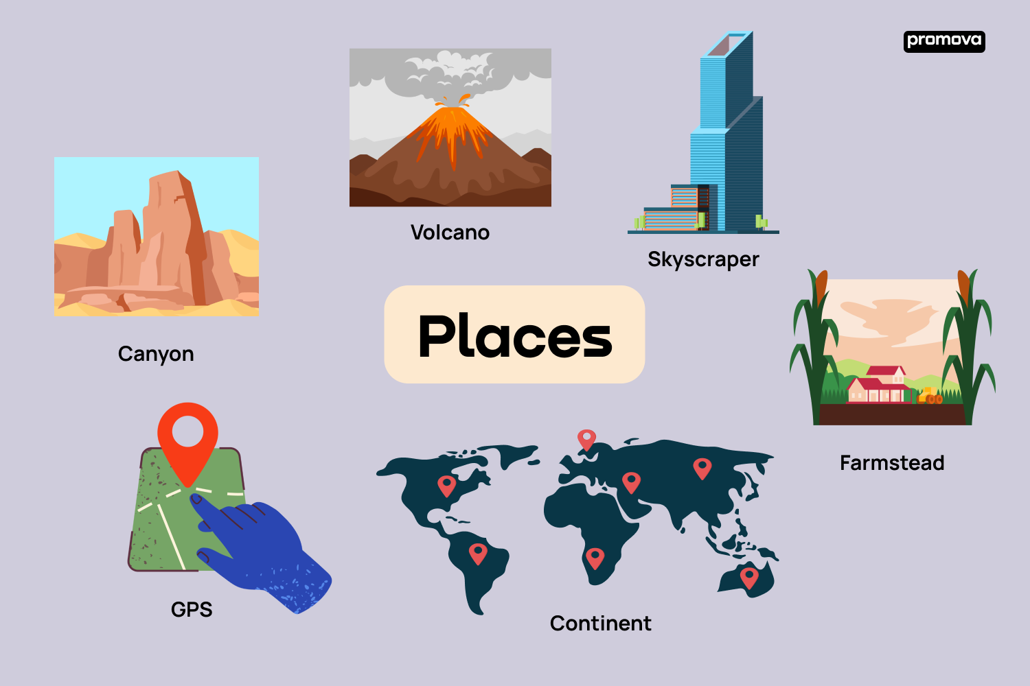
- Canyon. A deep gorge, typically one with a river flowing through it.
- Delta. A landform at the mouth of a river where it splits into several streams.
- Glacier. A slow-moving mass or river of ice formed by snow accumulation.
- Isthmus. A narrow strip of land with sea on either side, forming a link between two larger areas of land.
- Peninsula. A piece of land almost surrounded by water or projecting out into a body of water.
- Plateau. An area of relatively level high ground.
- Tundra. A vast, flat, treeless Arctic region in which the subsoil is permanently frozen.
- Valley. A low area of land between hills or mountains, often with a river running through it.
- Volcano. A mountain or hill with a crater or vent through which lava, rock fragments, hot vapor, and gas are being or have been erupted.
By learning these geographical terms, you have broadened your ability to describe and understand the physical world. These terms are not just for geographers but for anyone who wants to express the beauty and diversity of our planet. Keep these terms in your language toolkit, and you'll find it easier to connect with discussions about the environment, travel, and natural wonders.
Urban and Rural Settings
The contrast between urban and rural settings forms an essential part of our understanding of human geography. For language learners, knowing how to describe these environments is crucial for discussing lifestyle, culture, and societal structures. This section will guide you through key terms related to places in a city and rural settings, enriching your vocabulary and comprehension of human settlements.
- Metropolis. A large, densely populated city, often the major city in its region.
- Suburb. An outlying district of a city, especially a residential one.
- Hamlet. A small settlement, smaller than a village and typically rural.
- Skyscraper. A very tall building of many stories, typically in a city.
- Borough. A town or district which is an administrative unit, particularly in urban areas.
- Village. A group of houses and associated buildings, larger than a hamlet but smaller than a town, in a rural area.
- Downtown. The main business district of a city.
- Plaza. A public square, marketplace, or similar open space in a town or city.
- Farmstead. The main house of a farm and its outbuildings.
- Alley. A narrow passageway between or behind buildings.
With this city vocabulary, you're now better equipped to talk about various living environments and their characteristics. Whether it's a bustling metropolis or a tranquil countryside, your enhanced vocabulary will help you share experiences, stories, and discussions about different lifestyles. Remember, each term opens a window into a unique way of life and helps bridge the gap between diverse cultures and places.
Navigational and Directional Terms
Navigational and directional terms are fundamental in our daily lives, enabling us to explore, travel, and communicate locations. As a language learner, mastering these terms is crucial for giving and understanding directions, and discussing geographic locations. This section introduces essential navigational and directional vocabulary, vital for anyone navigating the world, both literally and linguistically.
- Latitude. The distance of a place north or south of the Earth's equator.
- Longitude. The distance of a place east or west of the prime meridian.
- Compass Rose. A figure on a map or nautical chart used to display the orientation of the cardinal directions.
- Cardinal Directions. The four main points of a compass. North, South, East, and West.
- Intermediate Directions. Directions such as Northeast, Northwest, Southeast, Southwest.
- Meridian. An imaginary line on the earth's surface from the North Pole to the South Pole.
- Equator. An imaginary line drawn around the earth equally distant from both poles.
- GPS (Global Positioning System). A satellite-based system for determining precise locations on Earth.
- Topography. The arrangement of natural and artificial physical features of an area.
- Landmark. A prominent object or feature in a landscape, used for navigation.
Now that you're familiar with these navigational and directional terms, you're better prepared to journey through the world of geography and travel. These terms not only enhance your ability to give and follow directions but also deepen your understanding of how we map and navigate our world. Keep these terms handy, and you'll find it much easier to engage in conversations about travel, geography, and exploration.
12
Types of Maps
Maps are a window to the world, allowing us to visualize geographical areas and various phenomena. As a language learner, understanding different types of maps will expand your geographic vocabulary and comprehension of places. This section introduces you to different types of maps, each serving a unique purpose in the world of cartography.
- Political Map. Shows countries, states, and cities, with borders clearly marked.
- Physical Map. Highlights natural features like mountains, rivers, and lakes.
- Topographic Map. Depicts the shape and elevation of terrain using contour lines.
- Climate Map. Displays information about the climate of different areas.
- Economic or Resource Map. Shows the distribution of various resources or economic activities.
- Road Map. Highlights roads, highways, and major transport links between places.
- Thematic Map. Focuses on a particular theme or subject area, such as population density.
- Weather Map. Provides data on meteorological conditions like temperature and precipitation.
- World Map. Represents the entire Earth's surface, often showing countries and major cities.
- Historical Map. Depicts the world or a region as it was at a certain period in history.
These types of maps offer diverse ways to view and understand our world. From navigating city streets with a road map to exploring ancient civilizations through historical maps, each type serves a unique and educational purpose. As you learn these terms, you're not just expanding your vocabulary but also gaining tools to better understand and describe the world around you.
Map Reading Elements
Map reading is a fundamental skill that combines understanding symbols, directions, and scales. For language learners, familiarizing yourself with the elements of map reading is essential for interpreting various types of maps accurately. Here, we explore the key elements you'll encounter in map reading.
- Legend. Explains the symbols and colors used on the map.
- Scale. Indicates the relationship between distances on the map and actual distances on the ground.
- Grid. A series of lines forming squares or rectangles to help locate places on the map.
- Compass Rose. A symbol indicating the cardinal directions (North, East, South, West).
- Latitude Lines. Horizontal lines on a map that show distances north or south of the Equator.
- Longitude Lines. Vertical lines on a map that show distances east or west of the Prime Meridian.
- Contour Lines. Lines that connect points of equal elevation, used in topographic maps.
- Map Key. Another term for legend, provides a guide to interpret map symbols and colors.
- Inset Map. A smaller map within the main map, often showing a detailed view of an area.
- Index. A list, often alphabetical, of places on the map with grid references.
Understanding these elements of map reading will enhance your ability to navigate and interpret various maps. Whether you're planning a journey, studying geography, or just satisfying your curiosity, these terms are key tools in your language learning toolbox. Remember, a map is more than just a picture; it's a gateway to understanding the complexities of our world.
Global Divisions
The Earth is divided into various geographical and political entities, each with its unique characteristics. As a language learner, knowing these global divisions enhances your understanding of world geography and international affairs. Here, we'll cover the terms related to the major global divisions like oceans and continents.
- Continent. A large, continuous mass of land. There are seven continents. Asia, Africa, North America, South America, Antarctica, Europe, and Australia.
- Ocean. A vast body of saltwater. The five oceans are the Pacific, Atlantic, Indian, Southern, and Arctic.
- Hemisphere. Half of the Earth, usually divided into Northern, Southern, Eastern, and Western Hemispheres.
- Equator. An imaginary line around the middle of the Earth, equidistant from the North and South Poles.
- Prime Meridian. The Earth's zero degrees longitude line, passing through Greenwich, England.
- Tropic of Cancer. A line of latitude about 23.5 degrees north of the Equator.
- Tropic of Capricorn. A line of latitude about 23.5 degrees south of the Equator.
- Arctic Circle. A line of latitude approximately 66.5 degrees north of the Equator.
- Antarctic Circle. A line of latitude approximately 66.5 degrees south of the Equator.
- International Date Line. An imaginary line on the Earth's surface defining the boundary between one day and the next.
Understanding these terms related to global divisions is crucial for a comprehensive grasp of world geography. They not only help identify and locate major areas on the globe but also enrich your conversations about different cultures and environments. As you continue to learn, remember that each term opens up a new perspective on how we view and understand our planet.
Conclusion
In this article, you've explored a wide range of places vocabulary. Remember, language is a bridge connecting cultures, experiences, and ideas. As you continue your language learning journey, let these terms guide you in exploring new horizons and expanding your global perspective.
FAQ
What are some essential places vocabulary words?
How can learning location vocabulary improve communication?
Why is it important to know place-related words in a new language?
What strategies can help in memorizing location vocabulary?
Make your next step to fluency with Promova


Comments